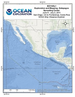
Okeanos Explorer (EX1103L1): Exploration and Mapping, Galapagos Spreading Center: Mapping, CTD, and Tow-yo
Vessel: NOAA Ship Okeanos Explorer; Expedition Dates: June 8 - July 2, 2011
Project Principals: Jeremy Potter, NOAA/OAR/OER (Expedition Coordinator); Elizabeth Lobecker, NOAA/OAR/OER (Mapping Lead)

This cruise was composed of two legs. During the first, the Okeanos Explorer collected multibeam and meteorological/oceanographic (METOC) data during the ~ 15.5 day transit from San Diego to the area of operations in the Galapagos Spreading Center. For the second leg, primary objectives included utilization of the full suite of Okeanos Explorer capabilities (i.e., ROV, mapping, CTD, and telepresence). Daytime operations focused on ROV dives to explore targets identified using bathymetry collected during Leg I and from other ships during previous expeditions. Nighttime operations consisted of vertical CTD casts and multibeam data collection.
Expedition Data and Resources
| Mapping Products | Download | Use zip utility to open file |
| Shipboard CTDs | Download | Use zip utility to open file |
| Ship Navigation Data (ASCII) | Download | Use zip utility to open file |
| Ship SCS/Sensor Data (ASCII) | Download | Use zip utility to open file |
| Ship SCS/Sensor Data (NetCDF) | Open | NetCDF file format: Special software needed to read |
Educational Resources
| Expedition Education Module | Open | Click to open Education Module |
| Lesson Plans (K-12) | Open | Click to open Lesson Plans |
| Education Materials Collection | Open | Click to open Education Materials |
Links to Archived Data and Resources
| Multibeam Archive Collection | Get Data | Click to Access Archive |
| Water Column Sonar Archive Collection | Get Data | Click to Access Archive |
| Physical, Chemical, and Biological Archive Collection | Get Data | Click to Access Archive |
| Collection of Documents | Get Data | Click to Access Archive |
| Expedition Metadata | Open | Click to view Metadata in xml format |

