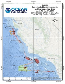
Okeanos Explorer (EX1101): Exploring California Seamounts and Archaeological Sites
Vessel: NOAA Ship Okeanos Explorer; Expedition Dates: March 16 - April 1, 2011
Project Principals: Elizabeth Lobecker, NOAA/OAR/OER (Expedition Coordinator and Mapping Lead)

Following a ship shakedown and mapping patch test, the EX conducted high-resolution multibeam mapping and water column exploration with CTD operations on seamounts and archaeological targets identified by the Sanctuary West Coast region and NMFS scientists. Shore-based scientists were able to work simultaneously with the ship via telepresence.
Expedition Data and Resources
| Mapping Products | Download | Use zip utility to open file |
| Shipboard CTDs | Download | Use zip utility to open file |
| Ship Navigation Data (ASCII) | Download | Use zip utility to open file |
| Ship SCS/Sensor Data (ASCII) | Download | Use zip utility to open file |
| Ship SCS/Sensor Data (NetCDF) | Open | NetCDF file format: Special software needed to read |
Educational Resources
| Education Materials Collection | Open | Click to open Education Materials |
Links to Archived Data and Resources
| Multibeam Archive Collection | Get Data | Click to Access Archive |
| Water Column Sonar Archive Collection | Get Data | Click to Access Archive |
| Trackline Data (Single-beam and Sub-bottom) | Get Data | Click to Access Archive |
| Physical, Chemical, and Biological Archive Collection | Get Data | Click to Access Archive |
| Collection of Documents | Get Data | Click to Access Archive |
| Expedition Metadata | Open | Click to view Metadata in xml format |

