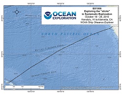
Okeanos Explorer Maximizing Operations (EX1006): Exploring the "sticks" in systematic exploration
Vessel: NOAA Ship Okeanos Explorer; Expedition Dates: October 18 - 28, 2010
Project Principals: Kelley Elliott, NOAA/OAR/OER (Expedition Coordinator); Elizabeth Lobecker, NOAA/OAR/OER (Mapping Lead)

The expedition objective was to map the bathymetry of the southern flank of the Line Islands in the vicinity of Kingman Reef and Palmyra Atoll, central equatorial Pacific for the U.S. Extended Continental Shelf (ECS) Task Force. The cruise mapped a total of 107,435 km2 in 22 survey days and collected 9942 line km of MBES lines with an average speed of 11.6 kn.
Expedition Data and Resources
| Mapping Products | Download | Use zip utility to open file |
| Shipboard CTDs | Download | Use zip utility to open file |
| Ship Navigation Data (ASCII) | Download | Use zip utility to open file |
| Ship SCS/Sensor Data (ASCII) | Download | Use zip utility to open file |
Educational Resources
| Education Materials Collection | Open | Click to open Education Materials |
Links to Archived Data and Resources
| Multibeam Archive Collection | Get Data | Click to Access Archive |
| Water Column Sonar Archive Collection | Get Data | Click to Access Archive |
| Physical, Chemical, and Biological Archive Collection | Get Data | Click to Access Archive |
| Collection of Documents | Get Data | Click to Access Archive |
| Expedition Metadata | Open | Click to view Metadata in xml format |

