
|
Ocean Exploration Notice of Funding Opportunity (NOFO) The following pages provide information about the Ocean Exploration Notice of Funding Opportunity (NOFO) expeditions conducted, and enables direct access to corresponding data and products. |
|
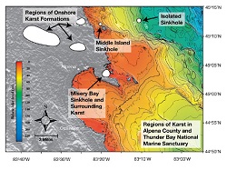
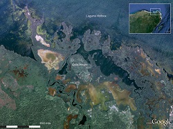
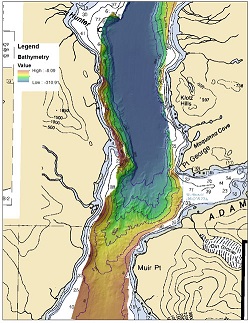
Exploration of Shallow and Deep Water Submerged Sinkhole Ecosystems in Thunder Bay NMS, Lake Huron: Habitat and Life The project team explored shallow and deep coastal sinkholes of the Thunder Bay National Marine Sanctuary to understand the chemical and physical properties that contributed to the unique ecologies in these systems. The team used remotely operated vehicles and divers to sample and characterize large areas of the sanctuary. In addition, they gathered data on the hydrology (the flow rates and dispersion), biology, and chemistry of submerged groundwater vents in northwestern Lake Huron. Specifically, the project team collected benthic samples of unusual microbial mats growing in very low oxygen conditions to determine how groundwater chemistry allowed them to thrive. They analyzed these samples for their potential application as pharmaceuticals. Using a moored hydrographic instrument array, the project team also improved their understanding of the groundwater's chemical and physical characteristics, such as conductivity (an indication of the presence of ions), temperature, and flow. Ultimately, the project enhanced the understanding of submerged groundwater vents in the Laurentian Great Lakes Basin. Funding for this project was provided by NOAA Ocean Exploration via its Ocean Exploration Fiscal Year 2008 Funding Opportunity. |
|
|
The Search for the Slave Ship Trouvadore and the U.S. Navy Ships Chippewa and Onkahye This project was driven by the hypothesis that ancestors of part of the present-day population of the Turks and Caicos Islands had arrived directly from Africa when the ship carrying them wrecked somewhere in the Caicos Islands. The team's archival research revealed that most of the 200 Africans saved from the Spanish slave ship Trouvadore in 1841 were integrated into the local community. Recognizing that a sizable proportion of the native population today were descendents from these survivors, the project team conducted an expansive search for the archaeological remains of Trouvadore. In addition, they located and identified the wrecks of two U.S. Navy ships, Brig Chippewa and Schooner Onkahye, that had engaged in anti-piracy and anti-slavery patrols in the Turks and Caicos Islands in the 1800s. The project gained community support, raised awareness about the maritime history and heritage of the region, and caught international media attention for its archaeological significance and findings. Funding for this project was provided by NOAA Ocean Exploration via its Ocean Exploration Fiscal Year 2008 Funding Opportunity. |
|
|
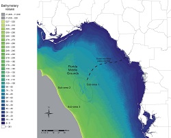
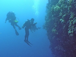
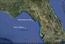
Deep-water Connections: Probing the Southern Limits of Distribution of North Atlantic Deep-Sea Coral Communities This project explored and characterized the diversity and abundance of octocorals, their commensals, and deep-sea fish living between 800 and 2,327 meters (2,625-7,635 feet) on the continental slope of the Bahama Platform east of southern Florida. During the expedition, the project team sampled and recorded videos and still imagery of deep-sea coral communities on the bathyal slope during 15 dives using the remotely operated vehicle Global Explorer. Video transects on each dive were used to map the distribution of octocorals and antipatharians and collect data on coral-associated species. The team also carried out lab-based work that included genetic analysis of octocorals and invertebrate associates and video analysis of octocoral morphology and fish distribution and behavior. The team discovered new species and novel ecologies, furthering our understanding of relationships between seafloor habitats and the distribution of invertebrates and deep-sea fish. Funding for this project was provided by NOAA Ocean Exploration via its Ocean Exploration Fiscal Year 2008 Funding Opportunity. |
|
|
Submarine Ring of Fire Explorations in the Western Pacific and Antarctic Oceans This three-year project included exploration of new volcanic arc sites in the western Pacific and Southern Ocean with a remotely operated vehicle and innovative exploration technology. It was a continuation and expansion of previous successful explorations of the often shallow and gas-rich volcanoes along intra-oceanic subduction zones. In the first year, the team's expedition to the southern Mariana arc explored a shallow water (80 meters/262 feet) vent site at Esmeralda Bank, a submarine volcano, and conducted surveys and dives at unexplored seamounts in the southernmost portion of the arc and backarc region. In the second year, they explored within the northern Lau Basin, looking for volcanic and hydrothermal activity. In the third year, they collaborated with the Korean Polar Research Institute. Using their new icebreaker research vessel Araon, they explored the Bransfield Strait, Deception Island submarine caldera, and the Antarctic Sound and located and mapped hydrothermally active sites. Funding for this project was provided by NOAA Ocean Exploration via its Ocean Exploration Fiscal Year 2009 Funding Opportunity. |
|
|
Continued Archaeological Investigation of Early Human Occupation of the Eastern Gulf of Mexico The purpose of this project was to reconstruct the potentially habitable Pleistocene landscape of western Florida from the Last Glacial Maximum (LGM) as it existed circa 22,000 years ago and persisted until it was entirely covered by sea-level rise. Using remote sensing survey techniques and diver examination of target locations, the team identified hundreds of relic landforms and examined many types of submarine features on the submerged inner continental shelf of western Florida, including intact river and stream channels, shore and nearshore deposits, karst sinkholes, and other recognizable terrestrial forms such as overbank deposits. The team's continued generation, processing, and analysis of exploratory data led to a fundamental evolution of our understanding of the timing and nature of the inundation processes since the LGM. Specifically, they changed our understanding of how these inundation processes might have influenced resource availability and potential exploitation patterns, among other human behaviors, from the time of the initial human colonizers of this area until their descendents had been pushed inland roughly 5,000 years ago. Rather than assuming an even, systematic reduction of available land and resources, the project team showed that inundation varied over time and that it would have had profound effects on the human inhabitants of the landscape. Funding for this project was provided by NOAA Ocean Exploration via its Ocean Exploration Fiscal Year 2009 Funding Opportunity. |
|
|
Exploring the Undersea San Andreas Fault: Uncovering the Past, Present and Future at the Centennial Upon the 100th anniversary of the Great 1906 Earthquake that nearly destroyed San Francisco, California, the project team explored and examined the Northern San Andreas Fault, which is the offshore boundary fault between the Pacific and North American plates that ruptured and caused the earthquake. Using high-resolution multibeam, sidescan, and multifrequency water column sonars, the team imaged the entire fault and subsurface transects across the fault to understand its deep structure and the evolution of the surrounding area. They deployed a near-seafloor autonomous underwater vehicle and a remotely operated vehicle to investigate areas of interest identified from the larger maps and collected samples of sediment and hard corals impacted by past earthquakes to establish the tectonic history of the fault. They also tested the use of an eco-friendly exploration vehicle primarily powered by sail. This project increased our knowledge about the relationship between tectonic history and biodiversity along the fault system and enhanced our understanding of how this unexplored but active geobiologic system may respond to possible future disturbances. Funding for this project was provided by NOAA Ocean Exploration via its Ocean Exploration Fiscal Year 2010 Funding Opportunity. |
|
|
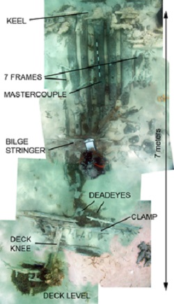
Pushing the Boundaries: Using Advanced Autonomous Underwater Vehicle Technology to Locate Historic Shipwrecks in Large Survey Areas To evaluate the potential of expanding the Thunder Bay National Marine Sanctuary (TBNMS), the project team proposed to develop an efficient and cost-effective remote sensing method for surveying large deep water areas with high-resolution imagery. Bringing together marine archaeology and engineering, the project team deployed and tested an advanced autonomous underwater vehicle (AUV) outfitted with a new generation of the Integrated Precision Underwater Mapping (iPUMA) sonar system developed by the Applied Research Laboratories at the University of Texas at Austin. The teams goal was to discover new shipwreck sites within the potential expanded boundaries of the TBNMS, identify bottom characteristics, locate marine habitats, and survey prehistoric archeological sites. With the help of a diver team, their fieldwork revealed unexpected evidence of human activities, including piles of large hunks of coal and snowmobile tracks. The project results supported the development of a more robust AUV system and informed management of the sanctuarys resources. Funding for this project was provided by NOAA Ocean Exploration via its Ocean Exploration Fiscal Year 2009 Funding Opportunity. |
|
|
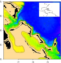
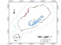
Search for Bermuda's Deep-Water Caves This project marked the completion of a three-year/three-phase mission to explore and characterize the upper edge of the Bermuda Platform and an adjacent mid-ocean seamount to confirm the existence of deepwater caves (~60-200 meters/197-656 feet depths) and to find records of low sea levels. The team conducted multibeam sonar mapping of the vertical cliffs on the platform edge, used remotely operated vehicles (ROVs) to examine points of interest (POIs or potential cave entrances), and deployed technical divers to observe and sample the geology and biology along the outer shelf-break edge of the submarine escarpment surrounding the Bermuda pedestal and adjacent seamounts. Through this project, they produced a high-resolution georeferenced map of the entire 180-kilometer (112-mile) perimeter of the Bermuda Platform and three-fourths of the Challenger Bank and also identified 161 POIs. During their fieldwork, they conducted ROV dives at 25 of the highest priority POIs and executed 10 technical dives to depths greater than 60 meters (197 feet) at the edges of the Bermuda Platform and Challenger Bank, including to a natural bridge cave (64 meters/210 feet), a drowned reef (60-63 meters/197-207 feet), a paleo sea-level notch (113 meters/371 feet) and jagged, possibly volcanic cliffs on Challenger Bank (137 meters/449 feet). The team also collected 250 samples of invertebrates, reef algae, and reef rocks from eight locations. Funding for this project was provided by NOAA Ocean Exploration via its Ocean Exploration Fiscal Year 2009 Funding Opportunity. |
|
|
The Costa Escondida Project: Exploring the Hidden World of the Maritime Maya The Costa Escondida Project was a long-term, interdisciplinary research endeavor that focused on the dynamic relationship between the Maya and their coastal landscape. Through mask and snorkel surveys and sediment sampling, the project team adopted the maritime cultural landscape approach to examine the complex interrelationship between human maritime activities and natural features and events and explore the adaptive subsistence strategies of the Maya at the human-coastal interface. By reconstructing life at the ancient coastal port of Vista Alegre, this project provided new data for Mayanists and Mesoamericanists and cross-cultural comparisons of port integration into larger political economies. It has generated scientific knowledge for social education about maritime history and for local partners to better protect and preserve their coastal and submerged cultural resources. Funding for this project was provided by NOAA Ocean Exploration via its Ocean Exploration Fiscal Year 2011 Funding Opportunity. |
|
|
Continued Archaeological Investigations of Early Human Occupation of the Eastern Gulf of Mexico (Cruise1of2) The project team identified over two thousand targets of interest on the inundated inner continental shelf along Florida's west coast in the northeastern Gulf of Mexico as a result of their 2008 and 2009 NOAA Ocean Exploration-funded fieldwork. Based on their hypothesis that submerged coastlines in the littoral zones of the eastern Gulf of Mexico contained intact beach features and indications of initial anthropogenic use of these environments, they carried out focused investigations to seek additional evidence of settlement and dispersal of late Pleistocene humans into and through the New World. Through targeted remote sensing, they explored channels and related geomorphological features of Florida west coast river systems that intersected with the submerged coastlines. They also deployed a remotely operated vehicle for verification and ground-truthing at deepwater sites. Their project shed new light on early human occupation and use of coastal paleo-environments. Funding for this project was provided by NOAA Ocean Exploration via its Ocean Exploration Fiscal Year 2011 Funding Opportunity. |

|
|
Ocean Exploration and Biotechnology on Pacific Deep Reefs This project involved technical diving, video and photo documentation, and collection of taxonomic samples in Chuuk, one of the four states of the Federated States of Micronesia, to survey, characterize, and assess deep reef communities, in particular their biodiversity and distribution patterns and the biopharmaceutical potentials of associated flora and fauna. Although deep-sea coral reef ecosystems are often biodiversity hotspots and potential refugia for many important shallow-reef species, they are underexplored due to various limitations. The Indo-Pacific deep reefs, specifically, encompass far more biodiversity than their counterparts in the Caribbean. This project resulted in a multidisciplinary bioassessment of Pacific deep reefs that can inform resource management. In addition, samples collected will be used for potential biotechnological development in the pharmaceutical and molecular markets. Funding for this project was provided by NOAA Ocean Exploration via its Ocean Exploration Fiscal Year 2010 Funding Opportunity. |
|
|
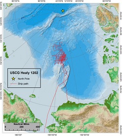
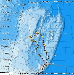
Arctic ECS Bathymetric Mapping This expedition is the ninth in a series of HEALY cruises dedicated to mapping and sampling regions of the Arctic north of Alaska that may qualify as "extended continental shelf" under Article 76 of the Convention on the Law of the Sea (UNCLOS). Total track covered on HEALY-1102 was 11,447 km (6181 nm) with 9188 km (4,961 nm) of multibeam sonar data and 875 km (472 nm) of seismic data. |
|
|
Continued Archaeological Investigations of Early Human Occupation of the Eastern Gulf of Mexico (Cruise2of2) The project team identified over two thousand targets of interest on the inundated inner continental shelf along Florida's west coast in the northeastern Gulf of Mexico as a result of their 2008 and 2009 NOAA Ocean Exploration-funded fieldwork. Based on their hypothesis that submerged coastlines in the littoral zones of the eastern Gulf of Mexico contained intact beach features and indications of initial anthropogenic use of these environments, they carried out focused investigations to seek additional evidence of settlement and dispersal of late Pleistocene humans into and through the New World. Through targeted remote sensing, they explored channels and related geomorphological features of Florida's west coast river systems that intersected with the submerged coastlines. They also deployed a remotely operated vehicle for verification and ground-truthing at deepwater sites. Their project shed new light on early human occupation and use of coastal paleo-environments. Funding for this project was provided by NOAA Ocean Exploration via its Ocean Exploration Fiscal Year 2011 Funding Opportunity. |
|
|
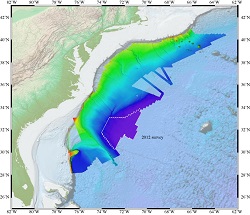
Atlantic ECS Bathymetric Mapping (RB1202) The 2012 Atlantic Extended Continental Shelf (ECS) bathymetry mapping cruise for the U.S. Extended Continental Shelf Project was the seventh ECS cruise to map the U.S. Atlantic continental margin. A transit was run from the South Area to Miami, FL. The cruise collected and mapped a total area of 69,287 km2. |
|
|
Johnston/Palmyra ECS Bathymetric Mapping The expedition objective was to map the bathymetry of two gaps in two submarine ridges in the vicinity of the Johnston Atoll in support of the Extended Continental Shelf Project. The cruise mapped a total of 97,250 km2 in 13.5 survey days and collected 6275 line km of MBES lines with an average speed of 11.6 kn. |
|
|
3D Visual Reconstruction for Rapid Archaeological Characterization The use of optical mapping has the potential to create accurate and vastly higher-resolution models of submerged archaeological sites with a fraction of the time and costs of traditional underwater survey means. This project involved the completion of a high-resolution survey of an internationally important submerged site (Port Royal, Jamaica) and scientists in the process produced a robust system of underwater survey for use by the archaeological profession to produce detailed, photorealistic plans and models of submerged sites quickly, economically, and to a level of accuracy comparable to that achieved on terrestrial sites. Funding for this project was provided by NOAA Ocean Exploration via its Ocean Exploration Fiscal Year 2014 Funding Opportunity. |
|
|
Bioluminescence in the Deep Sea Benthos II This project extended the exploration on vision and bioluminescence in the deep-sea benthos to the Gulf of Mexico using the remotely operated vehicle Global Explorer, which has excellent imaging and collection capabilities. Images taken during the NOAA Ship Okeanos Explorer 2012 Gulf of Mexico expedition suggested that there are numerous examples of cnidarian/crustacean symbioses, leading to the intriguing possibility that they too may be selectively feeding on pelagic organisms that impact the benthic structures, a virtually unexplored type of benthic/pelagic coupling. This project aimed to significantly expand the exploration of deep-sea benthic bioluminescence, examine interactions between vision and bioluminescence and benthic bioluminescence, and characterize the communities of organisms in two relatively unknown deep-sea habitats - one on the northern West Florida Escarpment and the other at the base of the West Florida Escarpment. Funding for this project was provided by NOAA Ocean Exploration via its Ocean Exploration Fiscal Year 2014 Funding Opportunity. |
|
|
Palmyra ECS Bathymetric Mapping KM1520 was leg 2 of the continuing long-term bathymetric mapping of the area around Kingman Reef and Palmyra Atoll, in the equatorial Pacific. The objective of the cruise was to collect bathymetric, acoustic backscatter, and sub-bottom data that might be useful to the U.S. A total area of 164,200 km2 (47,873 nmi2) was mapped (excluding transits) during the cruise in 22 survey days. |
|
|
Atlantic ECS Bathymetric Mapping MGL15-12 was leg 8 of the continuing long-term bathymetric mapping of the continental margin on the eastern seaboard of the U.S. The objective of the data that might be useful to support a potential submission by the U.S.under the U.N. Convention on the Law of the Sea, Article 76. |
|
|
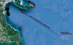
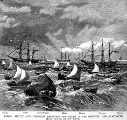
Search for the Lost Whaling Fleets of the Western Arctic This project involved conducting acoustic, magnetic, and video archaeological surveys and a small amount of core sampling in an area of the Chukchi Sea coast between Wainwright and the terminus of the Seahorse Islands, approximately 60 miles west of Barrow, Alaska. The surveys were targeting a place where, between 1871 and 1876, nearly 50 whaling ships were lost due to adverse ice conditions. The losses of these whaling ships were a major contributory factor to the demise of commercial whaling in the United States. This area is largely unmapped and unexplored, and therefore little is known about the potential physical remains of these wrecked ships. With increasing human activities in the Arctic as the ice diminishes due to climate change, underwater cultural heritage resources are potentially at risk from these activities. As this area has already been preliminarily proposed as a pipeline route for the Chukchi Sea oil and gas development area, it was essential to begin acquiring information about the presence of any shipwreck sites or physical artifacts that could be disturbed by this or other economic development activities in this region. The project was also potentially important with regard to the identification and establishment of marine protected areas in the Arctic. Funding for this project was provided by NOAA Ocean Exploration via its Ocean Exploration Fiscal Year 2014 Funding Opportunity. |
|
|
Hidden Ocean 2016: Chukchi Borderlands This project was part of a larger, multi-disciplinary group effort to explore marine communities from microbes to mammals and from sea ice to seafloor in a poorly known, bathymetrically and hydrographically complex Arctic region. As a group, scientists proposed a combination of photographic mapping using remotely operated vehicles, physical sampling, and state-of-the-art metagenomics to assess the diversity of this region. The focus of this module was to provide a taxonomic and biogeographic inventory of benthic invertebrate and fish communities across the complex Chuckchi Borderlands (CBL) region, as well as the marine mammal fauna of the region. Specifically, the project team explored whether the invertebrate and fish community of the CBL presents a biogeographic transition between Chukchi shelf fauna and the adjacent deep-sea fauna. Within this context, they were especially interested in the proportion of species of Atlantic origin because of the increasing influence of Atlantic water in this part of the Pacific Arctic sector. The CBL is a bathymetrically and hydrographically complex region, in which a field of pockmarks is a distinguishing benthic feature. One objective of this benthic module was to investigate these pockmarks for unique associations of invertebrate and fish fauna. Scientists also provided a link to higher trophic levels by observing the marine mammal community utilizing this region. Funding for this project was provided by NOAA Ocean Exploration via its Ocean Exploration Fiscal Year 2015 Funding Opportunity. |
|
|
Deepwater Exploration of Glacier Bay National Park Glacier Bay National Park (GBNP) protects unique deepwater fjords, internationally recognized as a refuge for many species of marine mammals and seabirds. What lives below the surface in the depths of the fjords, however, is still largely a mystery. The Red Tree Coral (Primnoa pacifica) has recently been found at shallow depths within the Park and a small black and white drop camera survey in 2010 showed the potential presence of three additional coral species in the park. Similar to tropical ecosystems, cold-water corals can form important habitats, creating oases supporting a wide diversity of life, making these cold-water corals areas important for GBNP's overarching marine diversity. Glacier Bay National Park may represent one of the few areas in the world where cold-water corals have been afforded de facto protection since 1925 (when the park became a National Monument), making their discovery an important one in terms of collecting baseline ecological data for potentially "pristine" environments - something as yet unobtainable for many cold-water coral habitats. This project focused on the central and east and west arms of GBNP and the unexplored remote fjords facing the outer Gulf of Alaska within the parks boundaries. Scientists also thoroughly explored and mapped a wide variety of habitats and examined the genetic continuity of populations of corals throughout this region. Funding for this project was provided by NOAA Ocean Exploration via its Ocean Exploration Fiscal Year 2014 Funding Opportunity. |
|
|
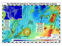
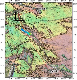
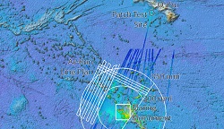
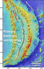
Exploring the Deep Mariana Back-arc Basin Within the US EEZ to Link Biodiversity, Geochemistry, and Geophysics More than 70 percent of volcanic activity on Earth occurs under the sea surface, and only a few percent of the volcanic seafloor environment has been explored. Back-arc settings are underexplored compared to mid-ocean ridge and volcanic arc settings and are therefore a priority for deep-ocean exploration today. In November to December 2015, the NOAA Pacific Marine Environmental Lab Earth-Ocean Interactions group started a two-part interdisciplinary exploration with the R/V Falkor of a vast area of the Mariana back-arc from 13 deg to 18.5 deg N and discovered four significant new hydrothermal vent fields. The 2015 expedition used CTD casts and tows to identify hydrothermal plumes in the water-column and the Sentry autonomous underwater vehicle to map the new hydrothermal sites. In addition, a previously unknown recent eruption site was discovered. For the second part of this project, on R/V Falkor with their new 4500-meter remotely operated vehicle, scientists returned to these newly discovered hydrothermal sites and collected baseline data on the seafloor to characterize their physical, chemical, and biological environments and processes. The data acquired from the new back-arc sites will help to test fundamental concepts about the role of geographic separation versus physical/chemical habitat characteristics in controlling macrofaunal and microbiological community structure. Funding for this project was provided by NOAA Ocean Exploration via its Ocean Exploration Fiscal Year 2016 Funding Opportunity. |
|
|
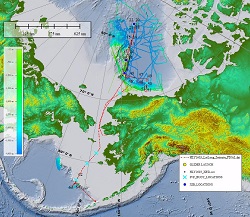
Arctic ECS Bathymetric Mapping In the Arctic, September 18 - October 5, 2016 NOAA OER and the University of New Hampshire Center for Coastal and Ocean Mapping sponsored the 10th and very likely final U.S. ECS field survey aboard U.S. Coast Guard Cutter Healy. Survey priorities included the collection of dredge samples on Alpha Ridge and the collection of bathymetric data in the region north of the Alaskan north slope margin and on the Beringian margin, aimed at strengthening our understanding of our countries' continental shelf outer limits. Approximately 14,000 km2 of seafloor were mapped and 27 kg (60 lbs) of rock were collected and catalogued. |
|
|
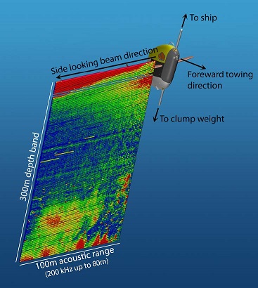
Integration of acoustic echosounding into the Wire Flyer profiling vehicle to investigate scattering layer distribution and oxygen coupling The Wire Flyer is a ship-towed autonomous profiling vehicle that slides up and down on a standard towed 0.322 cable using controllable wings for propulsion. The vehicle is able to profile at commanded vertical speeds between 0 and about 2.5 meters per second while being towed at a speed of between 3 to 4 knots. The system can operate over specified depth bands in the water column (e.g., 400 to 800 meters) and is not restricted to the upper few hundred meters like other towed undulating systems. This project integrated a side-looking split-beam multi-frequency echo-sounder into the Wire Flyer towed profiling vehicle for the purpose of providing unprecedented acoustic and environmental sampling resolution of midwater biomass. The motivation for the project was to exploit the high spatial resolution sampling capability of the Wire Flyer vehicle and provide complementary acoustic data in regions of the water column that have been traditionally under sampled. Funding for this project was provided by NOAA Ocean Exploration via its Ocean Exploration Fiscal Year 2017 Funding Opportunity. |
|
|
Peleliu's Forgotten WWII Battle The World War II battle for Peleliu is considered of such significance that the entire island was listed on the National Register of Historic Places and as a National Historical Landmark in 1985 and portions were evaluated for National Historical Park status in 1991 and 2003. This project made a significant contribution to our understanding of the amphibious invasion through the discovery, identification, and recording of battle sites. Two well known, but rarely integrated, avenues of marine science were used to characterize, identify, interpret, and analyze battle remains. The traditional deployment of a geophysical and remote sensing package (side-scan and magnetometer) coupled with the use of a small remotely operated vehicle and drone, where appropriate, were complemented by marine biological characterization of the coral reef structures that now host these sites. Funding for this project was provided by NOAA Ocean Exploration via its Ocean Exploration Fiscal Year 2017 Funding Opportunity. |
|
|
Collaborating with NOAA Laboratories to Advance Marine Environmental DNA (eDNA) Science Metabarcoding, a method of organism identification based on DNA, is often used to analyze marine environmental DNA (eDNA); however, questions remain with regard to optimal methods for extracting and assessing eDNA with minimal bias. The project team intended to improve existing eDNA methods and explore new frontiers in eDNA research in collaboration with NOAA. Their goals included comparing DNA primers, optimizing input DNA for metabarcoding, assessing cross-contamination risk during field collection, developing candidate metabarcoding primers for understudied taxa, and improving bioinformatic software pipelines for use by a broad range of users. The team conducted experimental work related to improving core methods by optimizing primer concentration, evaluating increased sequencing depth, measuring absolute eDNA concentration, and assessing nontarget eDNA effects. In experimental testing, the team found that including an internal standard in metabarcoding polymerase chain reactions can quantify absolute fish eDNA copies; this creates the potential to assess absolute fish abundance with metabarcoding. This project was funded by NOAA Ocean Exploration in fiscal year 2021 through a Broad Agency Announcement. |
|
|
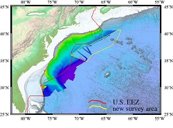
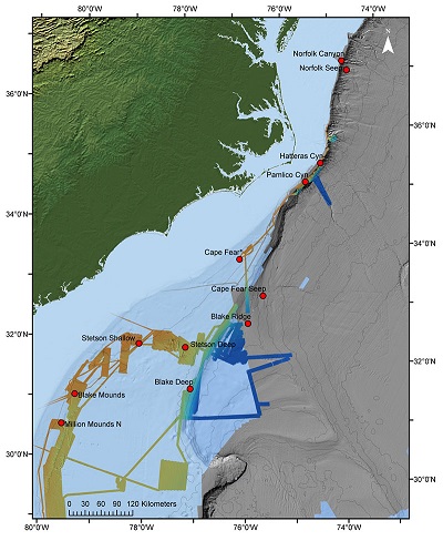
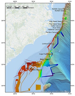
Deepwater Atlantic Habitats II: Continued Atlantic Research and Exploration in Deepwater Ecosystems with Focus on Coral, Canyon and Seep Communities (AT41) Between April 14 and May 10, 2021 EX-21-01 performed the sea acceptance testing of the newly installed Kongsberg EM 304 MKII transmit array, conducted mission readiness of the mapping systems through annual testing and calibration, and mapped unexplored areas of the Blake Plateau. In addition to the EM 304 multibeam sonar objectives, EK60/80 split-beam echosounder objectives included acceptance of the newly installed EK80 38 kHz transducer and calibration of each frequency (18, 38, 70, 120, 200 kHz). Other mission readiness objectives included ensuring functionality of all ancillary equipment, including sound speed profiling equipment, updating and refining procedural documents, and defining new procedures for supporting shore-based processing using the Cloud. EX-21-01 collected 22,187 square kilometers of bathymetry and associated water column data, with 18,773 square kilometers being within the U.S. Exclusive Economic Zone and Territorial Sea deeper than 200 m. |
|
|
Deepwater Atlantic Habitats II: Continued Atlantic Research and Exploration in Deepwater Ecosystems with Focus on Coral, Canyon and Seep Communities (BMCC18) This project aims to meet BOEM's urgent science needs in the Mid- and South-Atlantic planning areas, and involves collaboration among three federal agencies: BOEM, NOAA Office of Ocean Exploration and Research (OER), and the USGS. The project goal is to improve understanding of the planktonic and benthic communities (including corals) that reside in and around mid- and South-Atlantic canyon and cold seep habitats, including estimates of genetic connectivity among sites and trophic connectivity from the water column to benthic communities. |
|
|
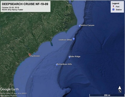
Deepwater Atlantic Habitats II: Continued Atlantic Research and Exploration in Deepwater Ecosystems with Focus on Coral, Canyon and Seep Communities (NF1909) The NF-19-09 expedition on board the NOAA Ship Nancy Foster was part of the multi-year Deep SEARCH project. This cruise occurred from October 21 to October 30, 2019. The cruise will focus on several seep sites, canyons, and hard bottom features located less than 100 nm offshore. This is the third research expedition associated with the Deep SEARCH project focused on exploring and characterizing seeps, corals, and canyon environments along the Atlantic margin. This project is a collaboration among three federal agencies: Bureau of Ocean Energy Management (BOEM), NOAA Office of Ocean Exploration and Research (OER), and the U.S. Geological Survey (USGS). TDI Brooks with academic partners has been selected to serve as BOEM contractor for this study. Data gathered during this mission and past cruises for this project will help inform multiple management issues concerning this region. The goal of this expedition was to recover benthic lander deployments, conduct mid-water trawling of the deep-scattering layer, collect water samples for christry and microbial diversity analyses, perform multibeam mapping at specific targeted areas, and collect sediment, water, and faunal samples for eDNA work. |
|
|
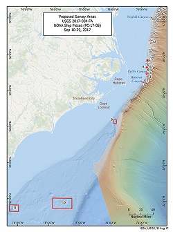
Deepwater Atlantic Habitats II: Continued Atlantic Research and Exploration in Deepwater Ecosystems with Focus on Coral, Canyon and Seep Communities (PC1705) This expedition is the first of three cruises for the Deep SEARCH project focused on exploring and characterizing seeps, corals, and canyon environments along the Atlantic margin. FY17-19 NOAA Ocean Exploration funds to support the DEEP Sea Exploration to Advance Research on Coral/Canyon/Cold seep Habitats (DEEP SEARCH) Project: DEEP SEARCH is an interagency collaboration NOPP project. BOEM initiated the work through its studies development plan and contracted TDI-Brooks International, Inc. through a competitive award process to conduct the research ($4000k approx. 3 year contribution); USGS identified five complementary research areas and will be supporting the participation of corresponding science teams on each expedition and contributing to the final study report ($4000k approx. 3 year contribution); NOAA Ocean Exploration has provided assets (ship, autonomous underwater vehicle or remotely operated vehicle) to support the research cruises, as well as the necessary expedition coordination, data management, and engagement support for each of those field efforts ($4000k approx. 3 yr contribution) for a total project value of approximately $12 million. |
|
|
Deepwater Atlantic Habitats II: Continued Atlantic Research and Exploration in Deepwater Ecosystems with Focus on Coral, Canyon and Seep Communities (RB1903) This project aims to meet BOEM's urgent science needs in the Mid- and South-Atlantic planning areas, and involves collaboration among three federal agencies: BOEM, NOAA Office of Ocean Exploration and Research (OER), and the USGS. The primary goals of this cruise are as follows: Exploration of new sites and new areas within known sites, sampling of corals and associated fauna for biodiversity and biogeography, community sampling at seep and coral habitats, sediment sampling at soft sediment sites for biogeochemistry and diversity, collections of corals for live coral experiments, water sampling for water chemistry and microbial diversity, sediment, water, and faunal samples for eDNA work, geological observations and sampling for geomorphology, lander deployments. |
|
")
