
Historic flash flood events juxtapose heat and expanding drought

Key Points

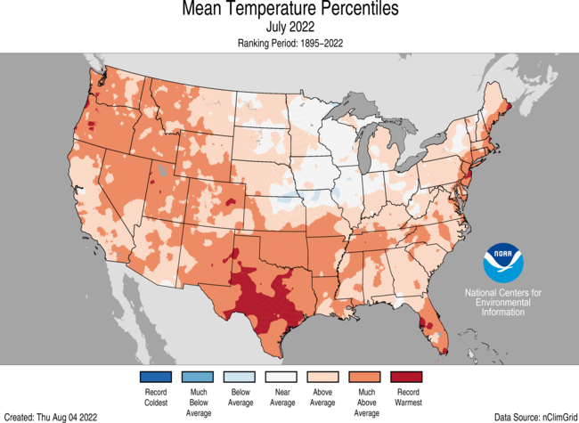
- The average temperature of the contiguous U.S. in July was 76.4°F, which is 2.8°F above average, ranking third warmest in the 128-year record. Generally, temperatures were above average and/or record-warm across nearly all of the Lower 48, with Texas having its warmest July, May-July and April-July on record.
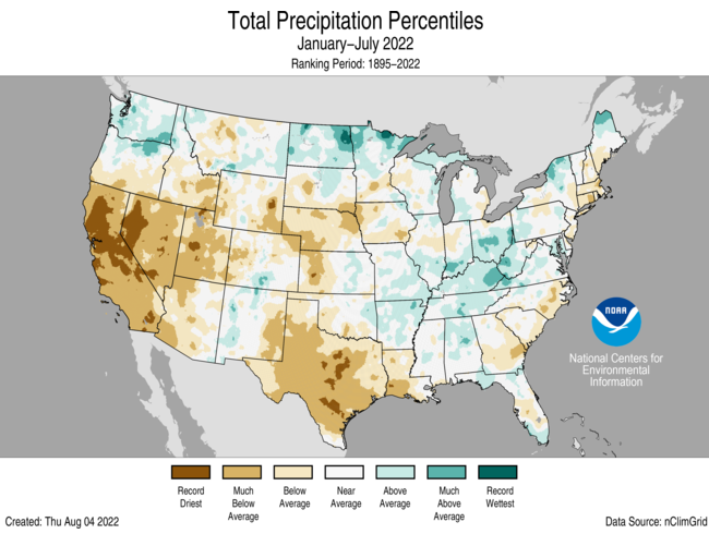
- July precipitation for the contiguous U.S. was 2.74 inches, 0.04 inch below average, ranking in the middle third of the historical record. Precipitation was above average in pockets across the West Coast, Southwest, Northern Rockies and Plains, Great Lakes and from parts of the Midwest to southern Appalachians. Precipitation was below average across portions of the Northwest, southern Plains, Upper Midwest and Northeast.
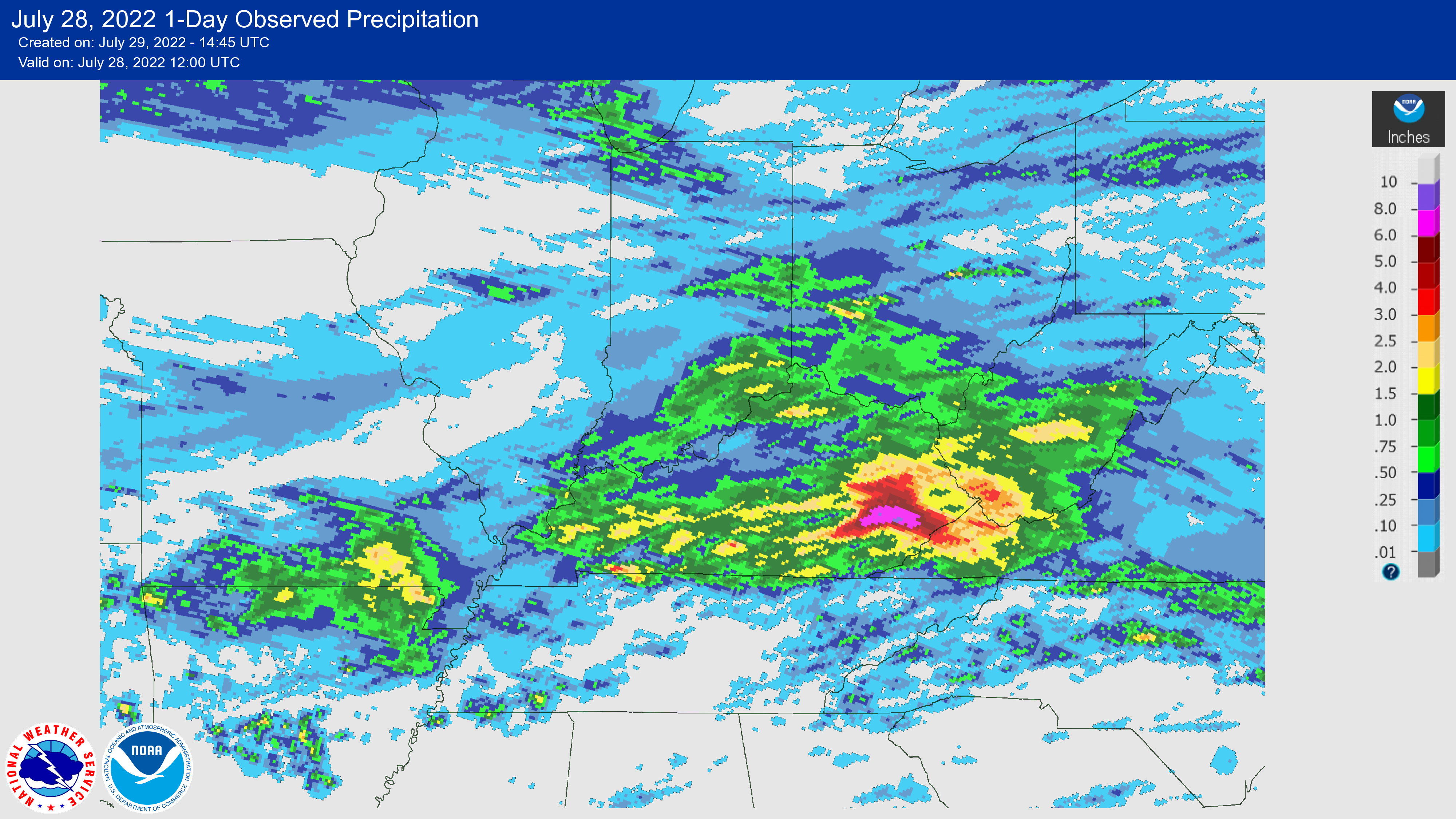
- A stalled frontal system, combined with rich Gulf moisture, resulted in historic flash-flooding events across portions of Missouri and Kentucky on July 26 and 28, respectively.
- Several heat waves, with daytime temperatures over 100°F, occurred across much of the U.S. during July, contributing to record energy demand and heat-related illnesses.
- The wildfire season appears to be waning across Alaska, but is still going strong across the West and southern Plains. Across all 50 states, more than 5.7 million acres burned from January 1 through July 31 — nearly 1.5 times the average for this time of year.
- According to the August 2 U.S. Drought Monitor report, 51.4 percent of the contiguous U.S. was in drought. Severe to exceptional drought was widespread from the Great Basin to the Pacific Coast and across portions of the central and southern Plains.
Other Highlights
Temperature

In addition to the record warmth across Texas, near-record warmth was widespread from the Pacific Northwest to the south-central U.S. and across parts of the Northeast. Oregon had its fourth warmest July, with six additional states experiencing a top-five warmest July on record.
For the January-July period, the average contiguous U.S. temperature was 52.7°F, 1.4°F above average, ranking in the warmest third of the record. Temperatures were above average from Oregon to the Gulf Coast and from the Gulf to New England. California and Florida each ranked sixth warmest on record for this period. Temperatures were below average across parts of the Upper Midwest.
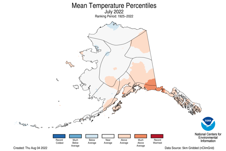
The Alaska statewide July temperature was 53.5°F, 0.8°F above the long-term average. This ranked among the warmest one-third of the 98-year period of record for the state. Temperatures were above average across portions of the Northeast Interior and across much of the south-central and southeastern portion of the state.
The Alaska January-July temperature was 28.6°F, 2.7°F above the long-term average, ranking in the warmest third of the record for the state. Above-average temperatures were observed across much of the state with portions of the North Slope and interior regions experiencing near-average conditions for this seven-month period.
Precipitation

Record rainfall received during the last week of July contributed substantially to the fourth-wettest July on record for Kentucky. Conversely, a lack of precipitation received during the month resulted in Rhode Island ranking second driest while Texas had its fifth-driest July on record.
The January-July precipitation total for the contiguous U.S. was 16.58 inches, 1.51 inches below average, ranking in the driest third of the historical record. Precipitation was above average across parts of the Northwest, northern Plains, Great Lakes and portions of the Mid-Mississippi, Ohio and Tennessee valleys. Precipitation was below average across much of the West, central Plains and Deep South during the January-July period. California ranked driest on record while Nevada and Texas ranked second driest and Utah, fourth driest for this seven-month period.
Alaska had the sixth-wettest July in the 98-year record. Much of the state received average to above-average precipitation during the month with portions of the Northeast and Southeast interior regions drier than average. The Cook Inlet region ranked wettest on record for the month. Talkeetna recorded its fourth-wettest July and Anchorage ranked fifth wettest on record. This rainfall put a quick end to most of the moderate drought across the state.
Precipitation averaged across Alaska for the January-July period ranked in the wettest third of the record and was generally above average across the North Slope and southeastern Alaska.The Central Panhandle region ranked wettest on record for the January-July period.
Other Notable Events
On July 26, several locations in and around St. Louis received more rainfall than on any other day on record. A stalled frontal system combined with tropical moisture resulted in precipitation totals that rivaled daily records set by the remnants of the Galveston Hurricane of 1915. Lambert International Airport reported 8.64 inches and St. Peters, MO, measured 12.34 inches of rain from this event. The extreme rainfall caused flash flooding, resulting in at least one fatality, as well as extensive damage to homes and businesses.
Flash flooding from the same stalled frontal system impacted portions of eastern Kentucky in the early morning of July 28. Heavy rain, enhanced by the terrain, accumulated rapidly, trapping many residents in their homes. Four to eight-inch totals were widespread across eastern Kentucky and the Kentucky River crested at all-time high levels in both Whitesburg and Jackson. At least 37 fatalities occurred with this event.
Cooler and wetter conditions across Alaska helped to reduce the spread of wildfires across the state during July. Additional significant wildfire growth is not expected for the remainder of the season, which is likely to rank as the seventh-largest season since 1950.
Drought
According to the August 2 U.S. Drought Monitor report, 51.4 percent of the contiguous U.S. was in drought, up about 3.7 percentage points from the end of June. Drought conditions expanded or intensified across portions of the Northeast, with flash drought rapidly expanding in the southern and central Plains, Ozarks and the mid-Mississippi Valley. Drought contracted or was eliminated across portions of the Southeast, Midwest, Southwest, and northern Rockies, as well as Alaska and Puerto Rico.
Monthly Outlook
According to the July 31 One-Month Outlook from the Climate Prediction Center, much of the West and from the Plains to the East Coast have the greatest chance of receiving above-normal temperatures in August, whereas the greatest chance for below-normal temperatures is projected to occur across portions of the Southwest and the southern half of Alaska. Parts of the Southwest, central Atlantic Coast and southeastern Alaska are projected to have the greatest chance of above-normal precipitation, while the greatest chance for below-normal precipitation is expected to occur from Texas to the northern Rockies and from the central Plains to New England. Drought is likely to persist across much of Texas, parts of the West, central Plains and Hawaii with some improvement and/or drought removal likely across parts of the Southwest, central Rockies, south-central Plains and Puerto Rico. Drought development is likely across portions of the Midwest and Northeast.
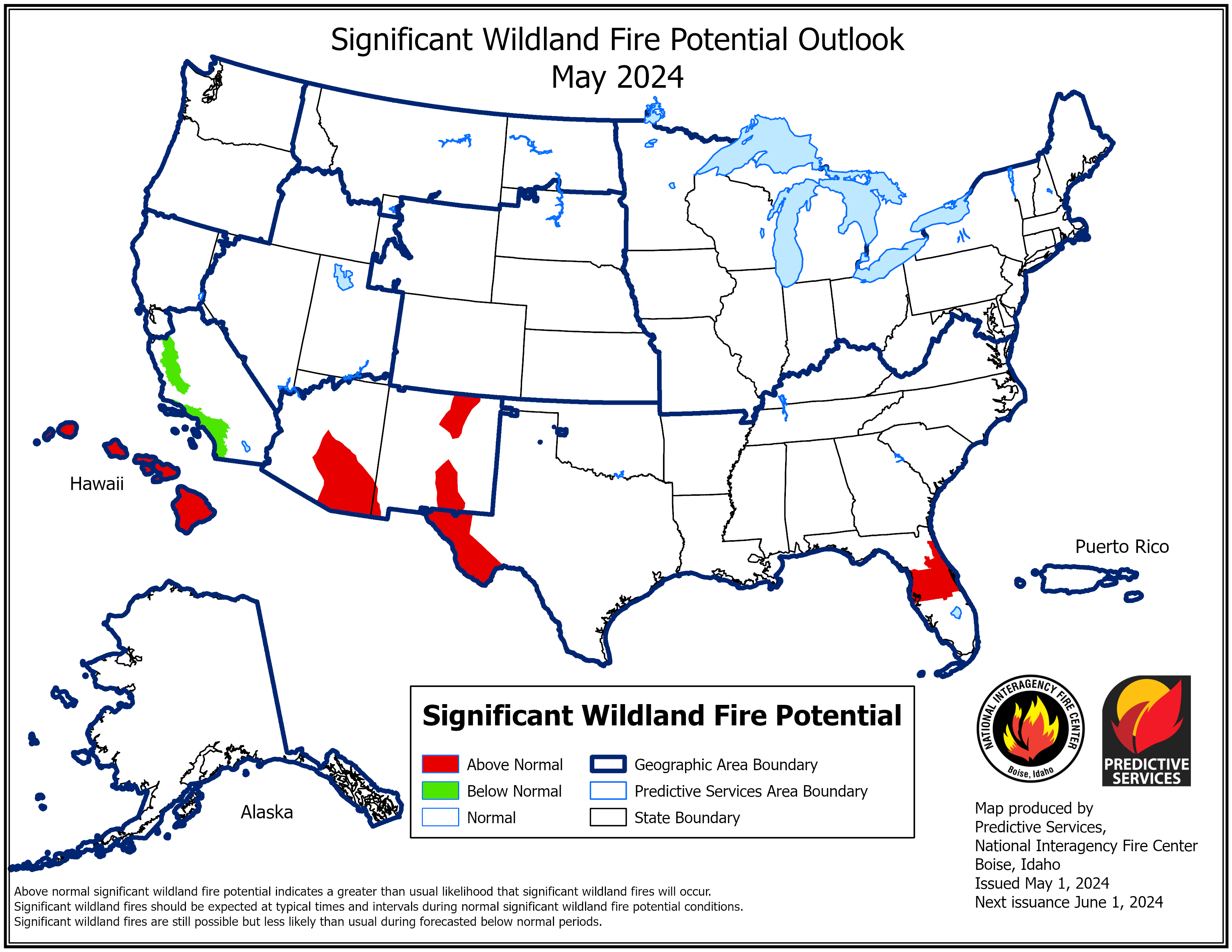
According to the One-Month Outlook issued on August 1 from the National Interagency Fire Center, Hawaii and portions of the West, north-central Plains, Midwest and southern Plains have above normal significant wildland fire potential during August.
This monthly summary from NOAA National Centers for Environmental Information is part of the suite of climate services NOAA provides to government, business, academia and the public to support informed decision-making. For more detailed climate information, check out our comprehensive July 2022 U.S. Climate Report scheduled for release on August 11, 2022.


