
Top-10 warmest January for contiguous U.S., Great Lakes ice cover well-below average

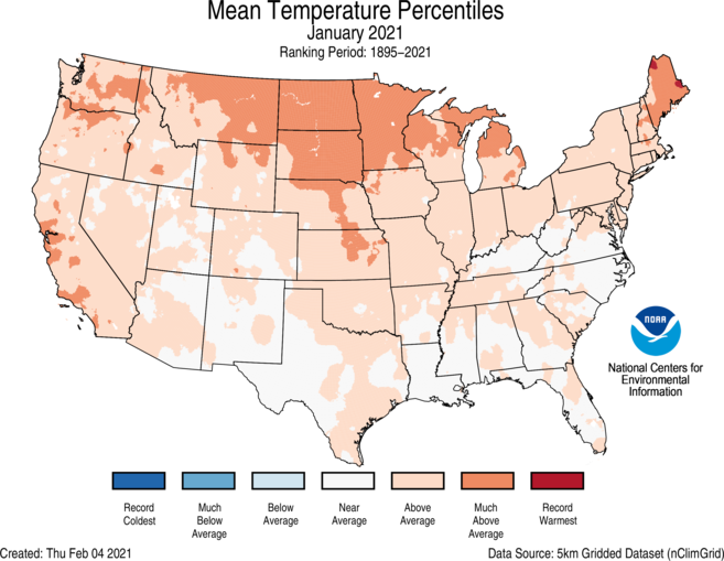
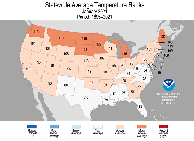
During January, the average contiguous U.S. temperature was 34.6°F, 4.5°F above the 20th-century average, tying for ninth-warmest January in the 127-year record. This was the 10th consecutive January with temperatures at least nominally above the 20th-century average for the month.
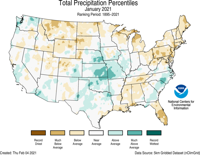
The January precipitation total for the contiguous U.S. was 2.01 inches, 0.30 inch below average, and ranked in the driest third of the 127-year period of record. Despite the dry conditions, an atmospheric river brought large amounts of rain and snow to portions of the West Coast January 27-29, which helped to alleviate some of the ongoing drought conditions in the region.

This monthly summary from NOAA National Centers for Environmental Information is part of the suite of climate services NOAA provides to government, business, academia and the public to support informed decision-making.
January Temperature

- Above-average temperatures were observed across much of the West, northern and central Plains, Great Lakes and Northeast. North Dakota and South Dakota ranked third and fifth warmest on record, respectively. No state across the Lower 48 ranked below average for the month.
- Above-average temperatures across the Great Lakes during the first two months of winter helped prevent ice from forming on the lakes. On January 24, only 2.4 percent of the entire lake surface was covered by ice. This is the lowest amount of ice coverage for this date in the last 48 years. Peak ice coverage is expected to span only 30 percent of the lake surface sometime from mid-February to early March. Average peak ice coverage is around 53 percent.
- The Alaska average January temperature was 11.0°F, 8.8°F above the long-term mean ranking 13th warmest in the 97-year record and was the warmest January since 2016. Temperatures across the state were consistently warmer than average with widespread areas in the interior regions 5°F to 10°F above average.
- Warm January temperatures contributed to the ninth-lowest Bering Sea ice extent in the last 43 years. This was lower than the last two years, but greater than the extent seen in 2017 and 2018.

January Precipitation

- During January, above-average wetness was observed across portions of the West Coast, central and southern Plains and parts of the Southeast.
- An atmospheric river, or a plume of concentrated moisture in the atmosphere, impacted the West Coast from January 27-29. More than 7 inches of precipitation fell from parts of southern California to the central California coast. The Sierra Nevada range received several feet of snow, closing down major highways. In addition to significant rain and snow, winds up to 125 miles per hour were reported near Lake Tahoe, California, as well as extensive power outages and mudslides across parts of the region. This event helped reduce some of the drought that has impacted coastal regions of the West Coast for many months.
- Below-average precipitation occurred across much of the Rockies, Northern Tier, Great Lakes, parts of the South and the Northeast.
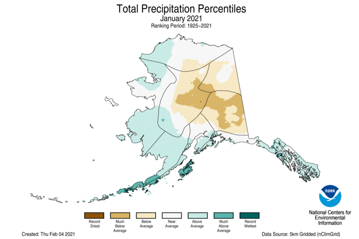
- Alaska ranked in the wettest third of the historical record for January. The interior regions were drier than average while the West Coast, Aleutians, Bristol Bay, the Northwest Gulf and the Panhandle had above-average precipitation.
- Fairbanks reported 0.5 inch of snow in January. This is the lowest January snowfall total on record for Fairbanks (since 1915).
- In the Panhandle, Ketchikan accumulated 77.64 inches of precipitation over the November to January period, which is 168 percent of average and the fourth-highest total on record for this three-month period.
- According to the February 2 U.S. Drought Monitor report, approximately 45.8 percent of the contiguous U.S. was in drought, which is approximately 3 percent less than at the end of December. Drought conditions expanded across portions of the northern Rockies and northern Plains and developed in parts of the lower Mississippi Valley. Improvements occurred across portions of the central Plains, Deep South, Southwest, and parts of the West Coast. Hawaii saw a 7 percent reduction in drought coverage, while Puerto Rico experienced some drought expansion during January.


