

NOAA and its partners have released the latest Regional Climate Impacts and Outlooks, which recap winter conditions and provide insight into what might be expected this spring.
Winter Temperature Recap
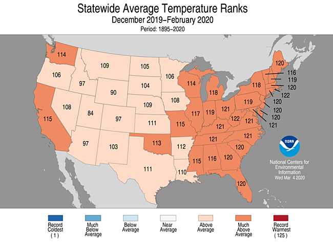
The Arctic Oscillation (AO) was strongly positive for most of the winter, particularly in January and February. Twice in February, it set all-time records for its highest values. As a result of this positive AO, winter temperatures were above average across most of the contiguous United States and much above average across the eastern United States. West Virginia and Rhode Island each had their fourth warmest December–February on record. Twenty-two additional states had a top 10 warmest winter.

Spring Temperature Outlook
According to the seasonal outlook from NOAA, warmer-than-average temperatures are most likely from coast to coast with the greatest chances in northern Alaska, across the central Great Basin southward into the Gulf States, and into the Southeast and portions of the Mid-Atlantic. No part of the country is favored to experience below-average temperatures this spring.

Winter Precipitation Recap
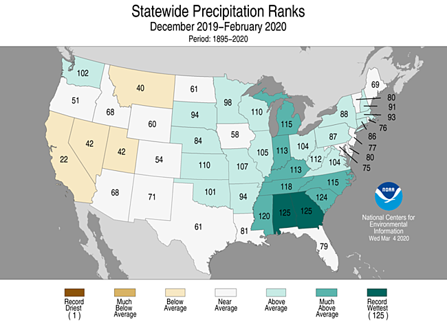
Much-above-average to record precipitation was observed from the Southeast into the Great Lakes. Alabama and Georgia ranked wettest on record for winter precipitation, while South Carolina ranked second wettest. Parts of the West and northern Rockies received below-average precipitation for the season.
Much of the Rockies, northern Plains, western Great Lakes, and northern New England received average to above-average snowfall during winter. The Sierra Nevada, the southern Great Lakes, and from the Ohio Valley to the Mid-Atlantic region and into the Northeast saw below-average to near-record low snowfall totals for the season.

Spring Precipitation Outlook
Record winter precipitation across a large swath of the country has set the stage for elevated flood risk, according to NOAA’s Spring Outlook. The upper Mississippi and Red River of the North basins have received rain and snow this spring up to 200 percent above normal.
The areas of greatest risk for moderate to major flooding include the upper, middle, and lower Mississippi River basins including the mainstem Mississippi River, Red River of the North, the Great Lakes, eastern Missouri River, lower Ohio, lower Cumberland, and Tennessee River basins.

Impacts and Outlooks for Your Region
Get more details for your region in the March 2020 climate impacts and outlooks summaries:
- Alaska and Northwestern Canada Region
- Chesapeake Bay Region
- Northeast Region
- Great Lakes Region
- Gulf of Maine Region
- Midwest Region
- Missouri River Basin Region
- Pacific Region
- Southeast Region
- Southern Region
- Western Region
Creating These Quarterly Summaries
NOAA’s Regional Climate Services lead the production of these quarterly summaries of climate impacts and outlooks for various regions of the United States as well as parts of Canada along the border. This effort, which began in 2012, now includes as many as 11 unique regional products, all produced collaboratively with partner organizations.
You can access all of the Climate Impacts and Outlooks summaries as well as additional reports and assessments through the U.S. Drought Portal Reports web page at Drought.gov.


