

NOAA and its partners have released the latest Regional Climate Impacts and Outlooks, which recap autumn conditions and provide insight into what might be expected this winter.
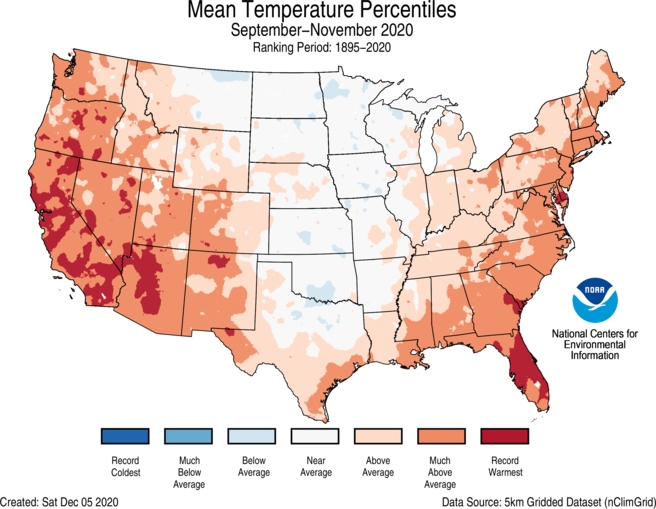
Autumn Temperature Recap
Above-average autumn temperatures spanned much of the West and from the Deep South to New England. California and Florida ranked warmest on record. Near-average temperatures for autumn were observed across much of the northern and central Plains as well as the western Great Lakes. The Alaska statewide average temperature for autumn was 28.4°F, 2.5°F above average, ranking in the warmest third of the historical record.

Three-Month Temperature Outlook
The January-February-March (JFM) temperature outlook favors below normal seasonal mean temperatures for approximately the southeastern quarter of mainland Alaska and the Alaska Panhandle, and from the Pacific Northwest eastward across the Northern Rockies to the Northern Plains. Maximum probabilities for below-normal temperatures exceed 50% over the extreme southeast portion of mainland Alaska, the Alaska Panhandle, and Washington state. Above-normal temperatures are favored across parts of northern and western Alaska, and for approximately the southern one-half of the contiguous United States, extending northward across the Ohio Valley, Central and Northern Appalachians, Mid-Atlantic, and Northeast. Maximum probabilities for above-normal temperatures exceed 60% across parts of the Southwest, Southern Rockies, and Southern Great Plains.

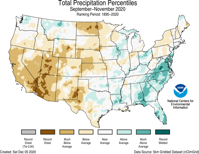
Autumn Precipitation Recap
Above-average precipitation was observed across the Southeast and mid-Atlantic as well as portions of the Northwest, South, Ohio Valley, and Great Lakes. Virginia ranked fourth wettest on record. Below-average precipitation was observed across much of the West, the northern and central Plains, and across parts of the Northeast. Utah and Arizona ranked driest on record for autumn with three additional states in the West and northern Plains ranking among their driest five autumns on record. Precipitation across Alaska during autumn ranked in the driest third of the historical record.

Three-Month Precipitation Outlook
The JFM precipitation outlook favors above-normal precipitation for most of the northern tier of the CONUS, extending southward from the Great Lakes across eastern portions of the Middle Mississippi Valley, the Ohio Valley, and the Central and Northern Appalachians. Above-normal precipitation is also favored for northern and western portions of Alaska. Maximum probabilities for above-normal precipitation exceed 50% over the Lower Ohio Valley. There are elevated odds of below-normal precipitation for approximately the southern one-third to one-half of the contiguous United States, and along the southern Alaska coast from the eastern Alaska Peninsula to the southern Panhandle region. Maximum probabilities of below-normal precipitation exceed 60% from southeastern Arizona to the Big Bend area of Texas, and over parts of northern Florida and southern Georgia.

Impacts and Outlooks for Your Region
Get more details for your region in the December 2020 climate impacts and outlooks summaries:
- Alaska and Northwestern Canada Region
- Chesapeake Bay Region
- Northeast Region
- Great Lakes Region
- Gulf of Maine Region
- Midwest Region
- Missouri River Basin Region
- Pacific Region
- Southeast Region
- Southern Region
- Western Region
Creating These Quarterly Summaries
NOAA’s Regional Climate Services lead the production of these quarterly summaries of climate impacts and outlooks for various regions of the United States as well as parts of Canada along the border. This effort, which began in 2012, now includes as many as 11 unique regional products, all produced collaboratively with partner organizations.
You can access all of the Climate Impacts and Outlooks summaries as well as additional reports and assessments through the U.S. Drought Portal Reports web page at Drought.gov.


